

Hello, designers! A road signage project plays a fundamental role in the safety, efficiency and organization of traffic on roads and urban areas. Therefore, it is essential that it is designed in accordance with current standards and regulations, always prioritizing the safety and efficiency of the signage system.
With that in mind, we've developed a complete guide that shows you, step by step, How to develop a road signage project from scratch to BIM., covering everything from the initial analysis stages to the modeling and organization of project information.

Throughout this content, you will realize that achieving this level of organization, precision, and compatibility with BIM is directly dependent on the use of... specialized tools, like the sinC, which make this process more practical, standardized, and aligned with the technical requirements of the sector.
Download the guide now to learn how to develop a road signage project, ensuring that you have access to the entire step-by-step process whenever you need it.
Importance of road signage design
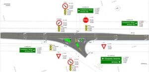
A road sign project is crucial to the safety and efficiency of traffic on roads and in urban areas. It not only guides drivers, pedestrians and cyclists, but also helps reduce accidents by ensuring orderly and predictable traffic flow. In addition, proper signage contributes to the fluidity of traffic, optimizing travel time and minimizing congestion. Here are some reasons why these projects are so important:
Accident Reduction
Road signs, when properly designed and implemented, help prevent accidents. Warning signs, speed limit signs and pedestrian crossings inform users of road conditions, allowing them to act appropriately and avoid collisions;
Guidance and Information
Signage projects provide essential information to drivers, cyclists and pedestrians. They indicate directions, places of interest, alternative routes and landmarks. Without this guidance, navigation would be confusing and chaotic;
Traffic Fluidity
Road signs help to keep traffic flowing smoothly. Without them, there would be confusion, congestion and delays. Traffic signs, traffic lights and lane markings help to keep traffic flowing smoothly and orderly;
Urban Organization
Signage projects take into account urban geography, population density and road usage patterns. They delimit parking areas, loading and unloading zones, and define traffic directions. This is essential for harmony between vehicles and pedestrians;
Awareness and Education
Road signs also play an educational role. They inform about traffic rules, priorities, and safe behavior. Well-designed projects encourage awareness and compliance with regulations.
In short, a road signage project is not just about signs and signals; it is about saving lives, facilitating mobility and promoting safe coexistence on public roads. Therefore, investing in signage projects is investing in the well-being of the entire community.
In addition to the importance that the signage project has within society, another aspect that is just as relevant is the step-by-step process of how to develop this type of project.
Follow the guide below on how to develop an efficient and aesthetically pleasing road signage project:
Analysis and diagnosis
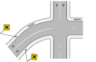
Start by understanding the context
Study the area where the signage will be installed. Consider the existing infrastructure, traffic flow, road characteristics (such as width, curves, slopes), the presence of pedestrians and cyclists, conflict zones, and any other factors that may be relevant.
Conduct a needs analysis
Identify existing problems, such as blind spots, traffic congestion, dangerous intersections, or lack of guidance. Consider factors such as traffic flow, population density, vehicle types, and hotspots.
Another good tip is to seek information from the Military Police, in police reports, about the nature of accidents that occurred in the segment in question. This way, you can look for signage design solutions to prevent new accidents.
For federal highways, this data is public. You can access it through this link: PUBLIC DATA ON ACCIDENTS ON FEDERAL HIGHWAYS.
Define the goals
Clearly define the project objectives. These may include improving safety, facilitating navigation, organizing traffic, or raising awareness.
Rules and Regulations
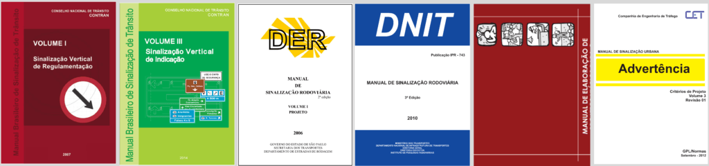
Find out which regulatory agency is under your jurisdiction. Check with the relevant agencies, such as the Department of Transportation, to ensure compliance. Some federations may have their own rules for their signs.
We have listed some examples of agencies that have their own manuals, and you can download these manuals by clicking on the links below:
- CET-SP (Traffic Engineering Company)
- DER-SP (São Paulo Department of Highways and Roads)
- BHTrans (Belo Horizonte Transport and Transit Company)
- DER-MG (Minas Gerais Department of Highways and Roads)
- DER-PR (Paraná Highway Department)
- CONTRAN (National Traffic Council)
- DNIT (National Department of Transport Infrastructure)
Never forget to check with the responsible bodies for possible updates to their rules, regulations and manuals.
What software should be used in a road signage project?
The development of a road signage project typically begins with a CAD platform, which serves as the basis for the preparation of technical drawings, implementation of elements, and compatibility with the geometric design of the road.
THE AutoCAD It is the most widely used platform on the market for this type of project, mainly due to its widespread adoption among designers, public agencies, and engineering companies. It allows the development of 2D projects with a high level of graphic control and compatibility with the main formats used in infrastructure works.
Already AutoCAD Civil 3D It is a solution specifically designed for infrastructure projects, such as highways, drainage, and earthworks. The main difference compared to traditional AutoCAD is that Civil 3D works with... intelligent modeling, Based on alignments, profiles, surfaces, and corridors. You can find some of our material discussing this difference below:
Regardless of the CAD platform used — whether AutoCAD, Civil 3D, or other solutions compatible with the DWG format (such as BricsCAD, GstarCAD, and ZWCAD) — these platforms are the foundation and are far from specific to our scenario of efficient development of road signage projects. This will therefore require specialized tools capable of automating tasks, ensuring regulatory compliance, and facilitating the transition from 2D to BIM.
In this context, the sinC acts as a essential complement It is compatible with the CAD platform, functioning as a plugin compatible with AutoCAD, Civil 3D, and other DWG-based software. It was developed specifically for road signage projects, allowing for the automated creation of horizontal, vertical, and directional signage, generation of quantities, technical detailing of signs, and also the transformation of the 2D project into BIM, all within the project environment already used by the designer.
Project development
Road signage projects are usually carried out based on a previously developed geometric design. However, in some cases, other forms of development may be adopted, such as point clouds or even satellite images. This is the responsibility of the geometry designer; always talk to this professional and other design disciplines to extract relevant information that may influence the signage design.
Based on the needs identified through the Analysis and Diagnosis and understanding of Rules and Regulations applicable, prepare the road signage project, considering the location of roads, permissions or not to overtake, intersections, pedestrian crossings and points of interest. Listed below are some common elements present in signage projects.
Horizontal Signaling
THE horizontal signage is a set of marks, lines, symbols, and legends painted directly on the surface of roads, such as streets and highways, with the aim of guiding, organizing, and controlling the flow of vehicles and pedestrians. This type of signage is essential to ensure safety and efficiency in traffic, providing clear and direct visual information to road users. Below are some existing types of horizontal signage:
LBO – Line on board
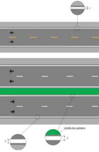
The edge line establishes the lateral, right and left limits of the runway. It provides better visibility conditions, delimiting the runway, especially at night or in adverse weather conditions, such as fog or rain.
ZPA – Zebras
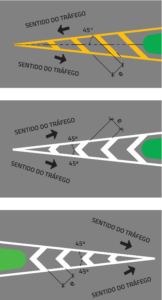
They are used to direct traffic flows on roads, ensuring greater traffic safety and better lane design. They regulate areas of pavement that cannot be used under normal operating conditions, the so-called neutral areas.
LCA – Pipeline:
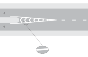
It delimits the pavement reserved for vehicle circulation, directing traffic flows for safety and fluidity reasons. It is normally accompanied by ZPAs to fill in unusable pavement areas.
LFO's – Lines of Opposing Flows
It divides opposing traffic flows, delimiting the space available for each direction and regulating the sections. There are variations of these lines, which are:
LFO-1
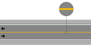
It divides opposing traffic flows, delimiting the space available for each direction and regulating the sections where overtaking and lateral movements are prohibited in both directions, except for access to adjacent properties.
LFO-2
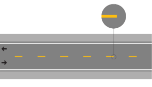
It divides opposing traffic flows, delimiting the space available for each direction and indicating the sections where overtaking and lateral movements are permitted.
LFO-3
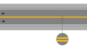
It divides opposing traffic flows, delimiting the space available for each direction and regulating the sections where overtaking and lateral movements are prohibited in both directions, except for access to adjacent properties.
LFO-4
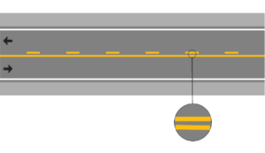
It divides opposing traffic flows, delimiting the space available for each direction and regulating the sections in which overtaking, crossing and lateral movement are prohibited or permitted.
You can download free AutoCAD horizontal road marking blocks to start your projects using our material below:
https://seabrasolucoes.com.br/blocos-cad-para-sinalizacao-horizontal/
Vertical Signage
THE vertical signage is a visual communication system used on public roads, consisting of signs and signals installed on posts or vertical supports along streets and highways. These signs provide important information to drivers and pedestrians, helping to regulate traffic, guide and ensure road safety. Vertical signage is classified into three main categories. They are:
Regulatory plates
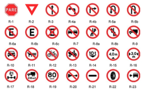
Regulatory signs are intended to indicate to road users the regulations that apply to the use of the road.
Warning signs
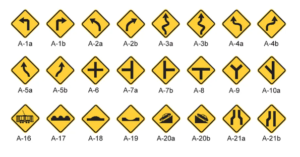
Warning signs are intended to provide advance warning of changes to the physical or operational characteristics of the highway, in order to warn users of the new situation. They should be used when changes occur unexpectedly or are difficult to see, during the day or at night, or for users to understand, and may affect safety conditions and traffic flow.
You can download free AutoCAD vertical signage blocks to start your projects using our material below:
https://seabrasolucoes.com.br/blocos-cad-para-sinalizacao-vertical/
Indicative signage plates
These are a type of vertical signage that provides useful information and guidance to road users, helping them navigate and recognize services, destinations and points of interest. These signs are designed to facilitate the orientation of drivers and pedestrians, allowing them to easily find specific locations or know the distance to a certain point. They can contain direction or distance directions.
Direction signs
They guide the driver through the different stages of their journey, providing the information needed to define the directions and directions to be followed to reach the intended destination. The legends used to identify the routes must be well-known by the population and must be based on an information system composed of a set of urban and rural landmarks of great public interest.
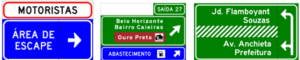
Distance guidance signs
These are a specific type of signage that provides information about the distance to specific destinations, helping drivers plan their routes and know how far they are from a point of interest. These signs are particularly useful on roads and highways, where accurate guidance is crucial for safe and efficient navigation.

Remember, choose colors, typography and icons that are legible, recognizable and consistent with traffic regulations. Signage should be clear and intuitive, even for those unfamiliar with the location. If there is an opportunity or need, seek out the responsible inspection agency to discuss proposed signage solutions. The role of these institutions is not only to monitor, but also to provide guidance. They have highly qualified professionals who are familiar with the needs of an avenue, road or highway. This information is also valuable for developing an effective road signage project.
You can download free dynamic signage blocks for AutoCAD to start your projects using our material below:
https://seabrasolucoes.com.br/diagramacao-de-placas-de-sinalizacao-vertical-no-autocad-ou-civil-3d/
Safety devices
These are devices installed longitudinally along the side of the road or as separators in the central reservation or on the edges of bridges, with the aim of containing, absorbing impact energy and redirecting out-of-control vehicles that leave the lane.
The guidelines for preparing road containment device projects are directly related to geometric characteristics, speed, traffic composition and significant presence of pedestrians and cyclists, among others, allowing the assessment of the need and the choice of the most appropriate type for the situation. They must comply with ABNT technical standards.
Among the various types of existing security devices, two types stand out in Brazil:
Metal fender
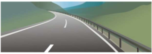
It is a continuous deformable protection device, consisting of a metal structure with a shape, strength and dimensions designed to contain and redirect out-of-control vehicles. The use of metal defense is determined by analyzing the characteristics of the location, according to criteria established in ABNT technical standards, which indicate the most appropriate model for the desired level of containment and the available work space in relation to the maximum deflection of the system.
Concrete barrier
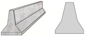
It is a rigid and continuous safety device installed along public roads to guide out-of-control vehicles back onto the track with decelerations that are bearable by the human body and minimize damage to the vehicles and the device itself. This helps to prevent accidents from worsening, such as head-on collisions after crossing medians, falls off cliffs and impacts against fixed elements, such as bridge pillars, posts and trees.
It is important to emphasize that these safety devices mentioned above are some of the options available to propose for road signage projects. It is possible to use other types of devices, as long as they are properly standardized by ABNT.
Approval and authorization
Once you have completed your project, submit it for approval to the competent authorities responsible for managing road signs in your region. Make sure you follow all the necessary procedures and requirements to obtain authorization to install the signs.
At this stage, it is possible that revisions may need to be carried out. This is normal and necessary to improve the effectiveness of the road signage project.
After this process, the project receives approval and moves on to the budgeting and execution phase.
Budgeting
This stage can sometimes be combined with the project delivery phase. However, regardless of whether or not it is necessary to deliver the project at this stage, budgeting plays a relevant role in the road signage project. Implementation costs are important when making the decision to use a particular road device.
To develop the budget for a road signage project, there are some price reference mechanisms that can be used:
SICRThe (Construction Reference Cost System):
This is a tool developed by the National Department of Transport Infrastructure (DNIT). SICRO is a reference document for preparing budgets and calculating costs in civil construction.
SICRO is a model that encourages competitiveness in the sector. Contractors can know, approximately, where a cost is unduly higher, allowing companies to prepare a fair and transparent budget.
SICRO provides cost references for public works budgets tendered by DNIT. The costs and prices listed in the table are separated by region of the country. Each region has its own table, and the information is further subdivided within each table by state.
TPU (Unit Price List)
It is a document that references the costs of various services and materials used in works and projects. It serves as a guide to estimate the total budget of a project, facilitating the planning and bidding process.
Some federations have their own TPUs, since input prices can vary greatly from one region to another.
It is always important to emphasize that before generating a budget for a road signaling project, it is crucial to seek the TPU reference to be used from the competent authorities. These tables are constantly updated considering inflation, therefore, it is extremely important to correctly seek the most up-to-date information available.
Implementation and Maintenance
Execute the project as planned, installing the signs, painting the lanes, and activating the traffic lights. Proceed with the implementation of the road signs according to the project specifications, which includes manufacturing the signs, installing the appropriate supports, placing the signs in the designated locations, and providing temporary signage during the installation process.
Establish a regular maintenance plan to ensure that the signage remains visible and functional.
Continuous assessment
Monitor the impact of signage: see if there has been an improvement in safety, traffic flow and reduction in accidents. Be open to adjustments and improvements as needed.
Remember that a well-executed signage project not only guides users, but also contributes to a safer and more organized community. Therefore, dedicate time and care to the development of this important urban aspect.
BIM has arrived
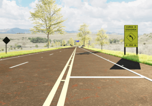
Previously unknown, a new stage in the process of a road signage project is beginning to be part of the daily lives of designers. Called BIM (Building Information Modeling), this methodology has revolutionized the way construction and infrastructure projects are conceived, developed and managed. When applied to road signage projects, BIM offers significant benefits:
You can download free 3D/BIM signage blocks for AutoCAD to start your projects using our material below:
https://seabrasolucoes.com.br/blocos-bim-3d-para-sinalizacao-vertical-dwg-download-gratis/
Integration and collaboration
The combined use of BIM and GIS (Geographic Information Systems) allows for the reduction of internal segregation between themes, simplifies workflows, and increases productivity. Furthermore, it facilitates collaboration with internal and external stakeholders. In other words, the interdisciplinary nature of signage and other disciplines in a road infrastructure project, such as drainage and paving, fosters constant interaction.
Automation and Precision
With BIM, it's possible to automate the transformation of conventional 2D signage designs into BIM format. This speeds up the process and improves the accuracy in representing signage elements.
Analysis and Improvements
BIM allows for detailed analysis before the construction phase. For example, it is possible to check for potential conflicts between disciplines, such as the position of signage in relation to other infrastructure elements.
Saving Time and Money
BIM modeling provides significant savings in time and resources, as well as allowing for the precise quantification of materials used in construction.
In short, BIM is a powerful tool for optimizing road signage projects, improving efficiency, quality and collaboration between those involved.
Levels of detail in BIM projects
Just like in the project development phases, the BIM methodology also requires some rules regarding levels of detail that must be followed. The inspection bodies have the autonomy to require what level of detail the BIM project must receive.
The purpose of LOD in BIM is to assess the quantity, quality and clarity of information available at a given stage of the project, essential for planning, budgeting, execution and maintenance of construction.
In Brazil, the Santa Catarina standard (SC-BIM Notebook) is based on the BIM Forum (aligned with the AIA), and is the only one that associates the LOD with the different phases of the project (feasibility study, preliminary study, preliminary design, legal, basic, executive).
THE SC-BIM Notebook uses a Development Level (DL) structure, ranging from DL-100 to DL-400, which covers everything from the initial design to detailing for the generation of construction documentation. In addition, there is DL-500, corresponding to the “As Built” stage.
Optimize your work
Use BIM tools to develop your signage project. Using specific plugins or software can automate the process of transforming 2D designs into BIM models.
Plan for the integration of signage with other design elements such as structures, landscaping, and infrastructure.
Remember that BIM is becoming an important trend in the design field, and mastering this methodology can put you ahead as a professional. Take advantage of the resources available, such as sinC software to develop efficient and accurate signage projects.
Conclusion
If you've come this far and want to delve deeper into the area of signage and become a specialized designer, get to know our complete training “from 2D to BIM in signage”. This course is ideal for both beginners who want to specialize in the development of urban and road signage projects, as well as for professionals who already have knowledge in the area, but seek to improve their methodologies with new market technologies, ensuring greater agility and practicality in the execution of their projects.
Frequently asked questions
What are the steps involved in developing a road signage project?
A road signage project typically goes through the stages of road analysis and diagnosis, definition of objectives, verification of applicable standards, development of horizontal and vertical signage, approval by the relevant authorities, budgeting, implementation, and maintenance. In more recent projects, conversion to BIM is also common, allowing for greater integration, precision, and information management.
What standards and bodies regulate road signage projects in Brazil?
Road signage projects in Brazil must primarily follow the guidelines of CONTRAN (National Traffic Council), DNIT (National Department of Transport Infrastructure), and the state DERs (Department of Roads), in addition to specific municipal regulations. Each agency may have its own signage manuals, so it is essential to verify the jurisdiction responsible for the road and always consult the most up-to-date versions of these regulations.
How to transform a road signage project into BIM?
Transforming a road signage project into BIM involves modeling the signage elements with associated technical information, such as dimensions, materials, and quantities. This process can be done using existing 2D designs and specialized tools – such as sinC – that automate the conversion to BIM and facilitate compatibility with other project disciplines.
Which software is best suited for developing road signage projects?
The development of road signage projects typically starts with a CAD platform, such as AutoCAD or Civil 3D; however, these tools are not specifically designed for signage. To increase productivity, ensure regulatory compliance, and facilitate the transition from 2D to BIM, it is ideal to use specialized tools, such as sinC, which complement the CAD platform and automate a large part of the design process.
See you later,


